Optical Survey Monitoring Consulting - NYC, Manhattan, The Boroughs, Nassau County, Suffolk County, Long Island, and New Jersey - Kagaoan Engineering

Optical Survey Monitoring Consultants
Kagaoan Engineering is the leading Tri-State provider of engineering expertise and technical equipment for monitoring ground displacement and construction progress. We work with the most recognized engineering professionals in Manhattan, Suffolk County, Nassau County Long Island, New Jersey, and Connecticut.
Our local partnerships provide valuable geotechnical services for monitoring soil and structural changes before, during, and after project completion.
Contact us
for free consultation.
Optical Surveying and Monitoring
Several specialized fields use optical survey monitoring to provide highly precise measurements in construction projects, remodeling, site preparation, excavations, and regular monitoring studies. With highly technical equipment like lasers, GPS monitors, and levels, geotechnical engineering specialists offer valuable assistance to firms in the construction, real estate, architecture, and forensic sectors. From preconstruction baselines to shifting numbers, engineering teams run optical survey information through many algorithms and software programs to give construction and engineering teams an in-depth look into current project conditions.
We provide assistance with small tasks like calibrating survey equipment for construction firms to large-scale projects requiring set-up and surveillance of multiple arbitrary points. Our team of optical survey monitoring consultants understands local ecosystems giving us invaluable experience and skills in the region. As a highly qualified team, we help our clients streamline the surveying process by acquiring permits and setting up monitoring stations and optical sensors.

What is Optical Survey Monitoring?
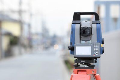
Engineering specialists select specific points to place laser eyes, guns, or reflectors. Any minuscule movement can affect positioning and measuring like traffic or on-site construction equipment. Engineers create survey mapping points and select the best places to put the optical equipment.
Data from this equipment goes through many software programs and monitoring systems to give work teams the necessary data to decide whether to continue excavations or make changes to the project.
Monitoring with Three-dimensional Technology
Understanding how construction projects and excavation jobs look in 3D gives our team of professionals access to real-time maps. Using advanced computer models and equipment, we can develop visual renderings of underground structures and conditions. This information gives project managers and developers the confidence to continue operations or make changes to the job.
Data Collection and Evaluation
When working with precise datasets and thousands of reference points, finding ways to sort and analyze the information is essential. Geotechnical specialists develop detection plans and software programs to capture data and organize it into easy-to-read reports. Our specialists can help architects and construction firms provide 3D renderings of the site putting a visual component to the data and giving the team a refined view of the situation. Some examples of construction projects using optical surveying include:
- Building and shoring up bridge embankments
- Trench digs
- Construction near existing structures
- Expanding buildings
- Digging wells
- Installing new roads
- Renovating existing businesses
Getting Precise Results Requires Hiring the Right Engineering Team
Many developments during construction projects can affect the results of the job. Subtle shifts in subsurface layers may not seem like a big deal to homebuilders or municipalities, but these changes can significantly impact the outcome of a project. Tracking these shifts can signal problems the team can avoid, or the information can give insight into the future of the project. Only a qualified team can determine whether the data represents a change that needs an immediate response or signals expected results.
Besides an understanding of the technical data, a specialized geotechnical team can save a business or organization hundreds or thousands of dollars. Efficient operations ensure a smoother job process and faster completion dates. Outside developers heavily rely on the experience of local engineering teams for applying for permits, setting up inspections, and meeting project deadlines. There are many factors that go into measurement accuracy:
- Ground settling
- Freezing and thawing cycles
- Road equipment
- Cranes and other construction machinery
- Regular traffic
- Improper placement of optical sensors
- Vibrations
- Wind changes
- Groundwater levels
- Putting sensors in areas too close to the construction
Count on the leading geotechnical team at Kagaoan Engineering for your optical surveying needs! When your developer or architect needs a pre-construction survey, the leaders in geotechnical engineering at Kagaoan Engineering are prepared to provide set-up, data collection, analyzing, reconfiguring, and graphical representations of the information. We work together as a local team to provide insight, technology, and education for builders and municipal partners needing help with optical monitoring. Our licensed, insured, and bonded technical providers give your business and organization peace of mind the job is in good hands.
Knowing the conditions above and below the surface are safe for new builds and upgrades is vital to meet local regulations. Optical survey monitoring consultants provide a precise technical service utilizing highly specialized equipment. When your Long Island or Nassau County company needs the skills of the region's leader, then call Kagaoan Engineering geotechnical engineering team. With decades of experience, precise measuring tools, and knowledge of the local ecosystem, we offer peace of mind and accurate reporting for any size project.
Please contact us
today for a free consultation.
About Kagaoan Engineering
Every member of Kagaoan Engineering is an experienced professional who brings distinct strengths and specialities to the company. We work together as team to ensure that your project has the skill sets required to succeed.

